South Lake Tahoe Snow Removal Route Map website - Pinnacle Lake Tahoe Getaways The snow removal route map can be accessed at www.cityofslt.us/snowremovalmap The City of South Lake Tahoe has launched a live snow removal route interactive map on the City’s website Continue Reading
Winter Weather Advisory
There is a winter weather advisory that will stay in affect until 5 a.m Sunday. A strong pressure over the the north Pacific will progressively move into our area. There will be periods of moderate and heavy snow in the northern sierra. Winds from the southwest Continue Reading
First Storms of 2011-2012 On The Way?
I know it is only September 27 but looking ahead with the aid of NOAA it appears there will be a major pattern change starting next week and lasting for a couple of weeks. The Pacific is starting to get active and the MJO which can bring storminess to the west coast is Continue Reading
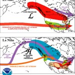
Another La Nina for 2012?
Synopsis: ENSO-neutral is expected to continue into the Northern Hemisphere fall 2011, with ENSO-neutral or La Niña equally likely thereafter. During July 2011, ENSO-neutral was Continue Reading
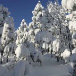
Big Tahoe Snows
Epic snowfall has been occurring the past 7-8 days with a ton more in the forecast. Check out some of these powder shots! Ten Feet in Tahoe from William Mauney on Vimeo. Continue Reading
Fall Storm-Lake Tahoe Snow?
I am back! Well things have started to get interesting early this fall with a few autumn-like systems affecting Lake tahoe since late August. Currently we are under our first advisory for snow which may bring as much as 8 inches to elevations above 8,000 fet and some as Continue Reading
Fantastic Mid-Winter Ski and Riding Conditions
Fantastic Mid-Winter Ski and Riding ConditionsImage via Wikipedia Fantastic Mid-Winter Ski and Riding Conditions in Lake Tahoe Lake Tahoe is having a banner snow year and the conditions for all Lake Tahoe resorts could hardly be better. It is obvious why Orbitz Continue Reading
Lake Tahoe Weather Forecast-November 5, 2009
Image via Wikipedia Howdy! I have been very lax about updating the Lake Tahoe weather post but now that we are deep into Autumn and everyone in town is looking up and waiting for those snowflakes to fall I decided I better get back on that horse! What appeared to be Continue Reading
Lake Tahoe Long Range Winter Forecast-El Nino Backing Off?
Lake Tahoe Long Range Winter Forecast-El Nino Backing Off? Starting this post has taken some time for me as I have been waiting for over two months to see the latest El Nino numbers. Today it appears that the El Nino that was predicted to become at least Continue Reading
Lake Tahoe Weather-El Nino Winter?
The squirrels have gone absolutely crazy eating and actually cutting pine cones from the trees in preparation for a HUGE South Lake Tahoe winter? Only time will tell but there are actual scientific indications for a big winter namely our old friend "El Nino" The El Nino is Continue Reading