If you are trying to pick a spot for your spring or summer vacation, there are MANY reasons why Lake Tahoe is the best spot to travel to. Not only is it a world class destination, but there is legitimately something for everyone all year around! But if you need some extra Continue Reading
What To Ask Before Booking Your Winter Vacation Rental
If you are thinking about booking a vacation rental in Lake Tahoe in the next few months, you may be thinking about blue bird days, hot beverages in a ski lodge and enjoying the nightlife as the snow falls. All of which sounds pretty dreamy to us! However, if you are booking Continue Reading
Fall Activities: Watch The Colors Change
While Lake Tahoe is mostly known for shades of blue, fall time is a local favorite for a few reasons. This is usually considered the "locals" shoulder season. Which means the town is quieter, the traffic has slowed and it feels like the locals get the town to themselves for Continue Reading
Lake Tahoe Weekend Update for March 9-14 2016
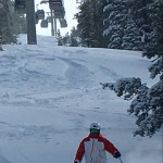
Lake Tahoe Fresh Snow Weekend Update 3/11-3/13/16 We have cabins open this weekend and lots of fresh snow to play in. Heavenly Mountain Resort reporting 21" of new snow in the last 72 hours Sierra At Tahoe reporting 42" of new snow since Continue Reading
Miracle March Possibilities of Great Snow in South Lake Tahoe
The forecast is looking hopeful for more snow to hit the high sierras. Check out Miracle March 2016 there are lots of different models pointing towards the possibility of great skiing/riding and playing ahead. Hopefully this will pull us out of the drought and fill Lake Continue Reading
Weather Update By- Chris Camacho
Good Sunday evening everyone, I hope all of you enjoyed the weekend. A shortwave trough was moving through California and Nevada today, which brought extensive cloud cover over Nevada as well as the breezy conditions to Tahoe. Conditions will remain similar to today for Continue Reading
CURRENT WEATHER UPDATE By-Chris Camacho
Good Sunday evening everyone! It has been a rather cloudy day for California, and an especially cloudy day for Nevada. The cloud cover and wet weather has been caused by a shortwave trough moving through California. The trough brought precipitation to the two states Continue Reading
Tahoe Basin – Air Conditions
Multiple fires are burning on the west side of the Sierra with the Valley, Butte, and Rough Fires being the largest, and producing the majority of the smoke we are currently seeing in the Sierra and western NV The Butte fire is located South of Highway 88, East of Highway Continue Reading
Early Lake Tahoe Snow–September 27, 2014
September 27, 2014 Snowing at Heavenly, photo courtesy of City of South Lake Tahoe. Continue Reading
Lake Tahoe Weather-September 19, 2013
National Weather Service Reno Nevada 307 am PDT Thursday Sep 19 2013 Synopsis... Light southeast winds and warmer conditions expected today and another night of below freezing morning lows is possible in the Sierra valleys tonight. A strong low pressure system Continue Reading
- 1
- 2
- 3
- …
- 5
- Next Page »