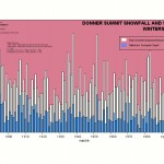
Wild Lake Tahoe Weather Continues....Epic Winter to Follow? The rain just keeps on coming. Lake Tahoe Weather.Now it is the talk of the really local locals who usually poo poo anything weather wise with a comment like....'back in 59 we had etc etc" But Continue Reading
Lake Tahoe Weather-Wild Thunderstorms, Flash Floods and Rain!
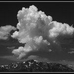
This has been an amazing week for weather at South Lake Tahoe! As a 30 year local of the Tahoe basin this may be the longest period of Thunderstorm activity that I can remember. This kind of activity usually occurs later in the summer during the southwest Monsoon season and Continue Reading
Big Lake Tahoe Snow Storms?
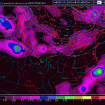
Big Lake Tahoe Snow Storms? Well, I have been away from this blog for a bit building a couple of new Lake Tahoe Vacation sites but I really wanted to get back and discuss the upcoming 7-10 days which may make for an epic March! The models are really Continue Reading
Champagne Powder For Presidents!
Champagne Powder For Presidents! Good morning! Another 6-10 inches of dry powder fell overnight in the Lake Tahoe region with a ton more on the way! The forecast calls for more snow this afternoon ( Wednesday) with an additional 6-10 inches in the works Continue Reading
South Lake Tahoe Weather Update-2-9-09
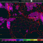
South Lake Tahoe Weather Update-2-9-09 Got Snow? The Lake Tahoe storm door is now officially wide open with a parade of increasingly strong storms forecast to slam into California and the Lake Tahoe basin. We received at our location over a foot of Continue Reading
South Lake Tahoe Weather Update-2/5/09
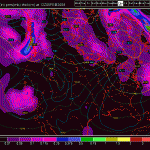
South Lake Tahoe Weather Update-2/5/09 The snow is back! The Lake Tahoe basin is seeing significant snow this morning with road controls up and the resorts receiving fresh powder with more on the way. The storm door appears to be wide open albeit with no Continue Reading
South Lake Tahoe Weather-Week of 2/1/09-2/8/09
The weather remains tranquil and warm for early February but changes may be on the horizon. Long range models show a pattern change beginning late in the week and precipitation in the form of low elevation rain and high elevation snow may fall beginning in earnest next Continue Reading
Lake Tahoe Weather-Changes Sooner Than We Thought?
Ok. I know I was pessimistic in the last post for Lake Tahoe weather but things may be changing for the better ( if you like weather) a bit sooner than even the models were indicating yesterday. For some reason the ensemble weather models are all showing some sort of low Continue Reading
Lake Tahoe Snow! A White Weekend Coming! 01/22/09
Lake Tahoe Snow! Finally it looks like we have a couple of decent storms brewing in the Pacific which may affect the Lake Tahoe basin and the High Sierra. At 6500 feet (my home) it is currently raining with a mix of heavy wet snow but it is snowing at Continue Reading
Lake Tahoe Snow Conditions-Reports
Lake Tahoe Snow Conditions-Reports The skiing and riding at Lake Tahoe should improve later in the week as the weather pattern changes for Lake Tahoe and the High Sierra. It appears that there may be 6-12 inches of new snow between Wednesday and Continue Reading