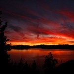
Skiing Is Great at Tahoe! Continue Reading
Great Late Winter Snowmobiling-South Lake Tahoe
The conditions for Lake Tahoe snowmobiling are absolutely incredible. With a near-record snow pack the riding should be epic well into May! [googleMap name="Flagpole Peak" width="525" height="525" directions_to="false"]1964 Nez Perce Drive, South Lake Tahoe, Continue Reading
Big Tahoe Snows
Epic snowfall has been occurring the past 7-8 days with a ton more in the forecast. Check out some of these powder shots! Ten Feet in Tahoe from William Mauney on Vimeo. Continue Reading
Carson Pass to Winnemucca Lake – Lake Tahoe Hiking Trails
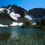
The trail from Carson Pass to beautiful 9,000 foot Winnemucca Lake is an area favorite, known for its gorgeous wildflowers and excellent views. This is a great hike for photographers, because of the picture perfect scenery, and people with dogs, because of the small Continue Reading
Five Lakes Trail – Lake Tahoe Hiking Trails
Five Lakes Trail - Lake Tahoe Hiking Trails Among the foothills of the Granite Chief Wilderness sprawls the Five Lakes Trail - an absolutely stunning and contemplative hike featuring five beautiful alpine lakes. Although this is a very popular one, the lakes allow you Continue Reading
Mt. Judah Loop – Lake Tahoe Hiking Trails
Lake Tahoe Hiking - Mt. Judah Loop Tahoe Hiking Trails This is a 4.6 mile loop that climbs the northeast face of Mt. Judah for some of the most impressive vistas in northern Tahoe Sierra. The recently popular Mt. Judah Loop Trail cuts off the Pacific Crest Trail and Continue Reading
Horsetail Falls – Lake Tahoe Hiking Trails
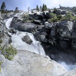
If you've ever taken Highway 50 to South Lake Tahoe, then chances are you've seen a gushing waterfall to the north just as you're approaching Echo Pass Summit. This spectacular fall is Horsetail Falls, created by Pyramid Creek flowing down the steep glacier carved Continue Reading
Clark Trail – Lake Tahoe Hiking Trails
Clark Trail - Lake Tahoe Hiking Trails For the more adventurous hiker, Clark Trail is a strenuous and solitary route that takes you from the southeast edge of Fallen Leaf Lake up the steep wooded hillside to Angora Lookout and Angora Lakes. The steep grades should be Continue Reading
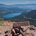
Stateline Fire Lookout – Lake Tahoe Hiking Trails
Stateline Fire Lookout - Lake Tahoe Hiking Trails The Stateline Fire Lookout, though often overlooked and off the beaten path, is beyond doubt the best high-elevation vantage point on Lake Tahoe's North Shore. This is an especially great place to bring your kids. A Continue Reading
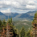
Heavenly Resort Hiking – Lake Tahoe Hiking Trails
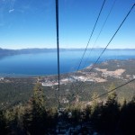
Heavenly Resort Hiking - Lake Tahoe Hiking Trails Many agree that Heavenly Ski Resort is some of the best skiing in Tahoe, and when the snow melts, there's still plenty to do on the mountain. Heavenly features three handsome hiking trails, varying in mileage and degrees Continue Reading
- « Previous Page
- 1
- 2
- 3
- 4
- 5
- 6
- …
- 9
- Next Page »