Join a group of adventurous mountain bike riders on the Corral Trail Night Ride Saturday October 17, 2015 5:30pm Costumes Encouraged, Lights Required http://www.tamba.org/corral-night-ride/ Meet at the Corral parking are at 5:30 pm. We’ll take Continue Reading
Sept. 13 2015 Music In The Park–Tahoe Paradise Park

Live music in Tahoe Paradise Park Great setting on the edge of Lake Baron in Tahoe Paradise Park South Lake Tahoe Tahoe Paradise Park Food, Beer Garden, room for the kids to roam and play. 40 Watt Hype today 9/13/15 starting at 4:00pm Here is a Continue Reading
August 11-17 South Lake Tahoe Cabins Available
Lake Tahoe is the perfect place for a quick weekend getaway, and August is the perfect timing to visit because the town isn’t too busy but the weather is still amazing. From beach days to concerts, stunning hikes to gourmet dinners, South Lake Tahoe is the place to be if you Continue Reading
Lake Tahoe Activities-What to do in Lake Tahoe: Labor Day Weekend 2014
South Lake Tahoe is gearing up for a fun filled Labor Day Weekend. After a hailstorm on Monday the weather is supposed to be gorgeous and there is a lot going on, here are just a few ideas. Sunday from 12-5:00pm Sample local restaurants paired with regional Continue Reading
Hike for Housing Fundraiser
Hike for Housing Fundraiser Hike for Housing Fundraiser for: Habitat for Humanity & Saint Joseph Land Trust Participate in the annual Hike for Housing on Saturday, September 15, 2012 at Spooner Lake Park! Hike around Spooner Lake or choose to do the Continue Reading
Outdoor Reggae Festival at Mont Bleu
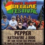
Check it out! Mont Bleu and PR Entertainment will be hosting their first event in the newly renovated outdoor amphitheater on June 30th. The Lake Tahoe Reggae Festival is an all day event for all ages. The line up include Pepper, Katchafire, J Boog from Hawaii, Continue Reading
Horseback Riding-Stables
Piping Rock Equestrian Center Continue Reading
9th Annual Telegrass Festival
Come enjoy sunshine, bluegrass music and Telemark equipment demos all day today at Sierra at Tahoe. This is Sierra's 9th annual Telegrass Festival where you can register to participate in Telemark clinics for all levels of experience. Afterwards, stomp your feet to some Continue Reading
Disc Golf at Lake Tahoe
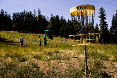
One of the best ways to enjoy the amazing weather we have in Lake Tahoe is to head out with some friends and play a round of disc golf. It is a great way to enjoy nature and spend some time outside on a beautiful day. There are three different courses in the Lake Tahoe area Continue Reading
St. Patty’s Day and More Snow!
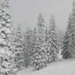
Happy St. Patrick's Day and we are super fortunate to have all this powder dumped on us for the weekend. It is easily the biggest weekend of snow so far this season. The biggest and coldest storms of the week moved in last night. We could see another Continue Reading
- « Previous Page
- 1
- 2
- 3
- 4
- 5
- …
- 9
- Next Page »